


Daggett Voting District, Daggett County, Utah
About
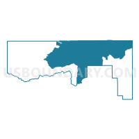
Outline

Summary
| Unique Area Identifier | 678603 |
| Name | Daggett Voting District |
| County | Daggett County |
| State | Utah |
| Area (square miles) | 287.21 |
| Land Area (square miles) | 266.72 |
| Water Area (square miles) | 20.50 |
| % of Land Area | 92.86 |
| % of Water Area | 7.14 |
| Latitude of the Internal Point | 40.92706860 |
| Longtitude of the Internal Point | -109.40311440 |
Maps

Graphs
Select a template below for downloading or customizing gragh for Daggett Voting District, Daggett County, Utah


Neighbors
Neighoring Voting District (by Name) Neighboring Voting District on the Map
- Ashley East Voting District, Uintah County, UT
- Blairtown Voting District, Sweetwater County, WY
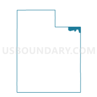
- Browns Park Voting District, Daggett County, UT
- Jensen Voting District, Uintah County, UT
- Maeser Dryfork A Voting District, Uintah County, UT
- Manila Voting District, Daggett County, UT
- Moffat 4, Moffat County, CO
- WASHAM Voting District, Sweetwater County, WY
Top 10 Neighboring County Subdivision (by Population) Neighboring County Subdivision on the Map
- Vernal CCD, Uintah County, UT (26,835)
- Green River South CCD, Sweetwater County, WY (3,709)
- West Daggett CCD, Daggett County, UT (886)
- Maybell-Powder Wash CCD, Moffat County, CO (322)
- East Daggett CCD, Daggett County, UT (173)
- Rock Springs South CCD, Sweetwater County, WY (147)
Top 10 Neighboring Place (by Population) Neighboring Place on the Map
Top 10 Neighboring Unified School District (by Population) Neighboring Unified School District on the Map
- Uintah School District, UT (32,588)
- Moffat County School District RE-1, CO (13,795)
- Sweetwater County School District 2, WY (13,657)
- Daggett School District, UT (1,059)
Top 10 Neighboring State Legislative District Lower Chamber (by Population) Neighboring State Legislative District Lower Chamber on the Map
- State House District 57, CO (78,537)
- State House District 55, UT (38,435)
- State House District 53, UT (37,757)
- State House District 18, WY (9,703)
- State House District 17, WY (9,400)
Top 10 Neighboring State Legislative District Upper Chamber (by Population) Neighboring State Legislative District Upper Chamber on the Map
- State Senate District 8, CO (148,629)
- State Senate District 26, UT (101,392)
- State Senate District 14, WY (19,890)
- State Senate District 12, WY (17,585)
Top 10 Neighboring 111th Congressional District (by Population) Neighboring 111th Congressional District on the Map
- Congressional District 2, UT (890,993)
- Congressional District 3, CO (706,186)
- Congressional District (at Large), WY (563,626)
Top 10 Neighboring Census Tract (by Population) Neighboring Census Tract on the Map
- Census Tract 9682, Uintah County, UT (7,450)
- Census Tract 9683.02, Uintah County, UT (4,568)
- Census Tract 9707, Sweetwater County, WY (3,709)
- Census Tract 9716, Sweetwater County, WY (2,092)
- Census Tract 6, Moffat County, CO (1,608)
- Census Tract 9601, Daggett County, UT (1,059)
Top 10 Neighboring 5-Digit ZIP Code Tabulation Area (by Population) Neighboring 5-Digit ZIP Code Tabulation Area on the Map
- 82901, WY (27,971)
- 84078, UT (25,851)
- 84046, UT (793)
- 84023, UT (266)
- 81640, CO (249)
- 82938, WY (227)